Location - Omagh Model Flying Club
Main menu:
Location
 Location

Directions to Omagh Model Flying Club
----------------------------------------------------------------------------------------------------
From Belfast drive into Omagh on the A5 and continue on this road signposted for Derry until you reach the Derry Road Roundabout then
At Derry Road Roundabout, take the 1st exit onto B50/Gillygooley Road
Drive along this road for approx 3.7 miles
Turn right onto Claragh Road
Drive along this road for approx 1.1 miles
Turn right onto Laght Rd
Drive along this road for approx 0.7 miles. (Signposted)
Turn right onto lane where OMFC flying site is situated. (Signposted)
----------------------------------------------------------------------------------------------------
From Derry drive into Omagh on the A5 until you reach the Derry Road Roundabout. (First roundabout that you will come to)
At Derry Road Roundabout, take the 3rd exit onto B50/Gillygooley Road
Drive along this road for approx 3.7 miles
Turn right onto Claragh Road
Drive along this road for approx 1.1 miles
Turn right onto Laght Rd
Drive along this road for approx 0.7 miles. (Signposted)
Turn right onto lane where OMFC flying site is situated. (Signposted)
---------------------------
Latitude:54.625348
Longitude:-7.408111
Google Maps
The closest postcode to our location is BT78 4TZ
OUR LOCATION
Where our club is located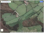
see location page
LINKS
Links to other related websites
FOLLOW US

Local clubs

Facebook
Organisations

You Tube
Various links

Twitter
